


 User Center
 My Training Class
 Feedback


As we track a current system (read more here) bringing impacts across the Mid-west and Ohio Valley, the next region expected to see impacts will be the Mid-Atlantic. There are already winter watches and warnings into the Appalachia area for what could possibly be a significant ice threat.
Winter Weather Alerts
From tonight and into tomorrow morning, winter storm warnings (pink) and winter weather advisories (purple) have been issued for those that are expected to see impacts from this winter storm. If you are under a winter storm warnings we expect some of our more significant ice totals (up to 0.5″) as well as snow totals (up to 2″). For the forecast accumulation, scroll down.


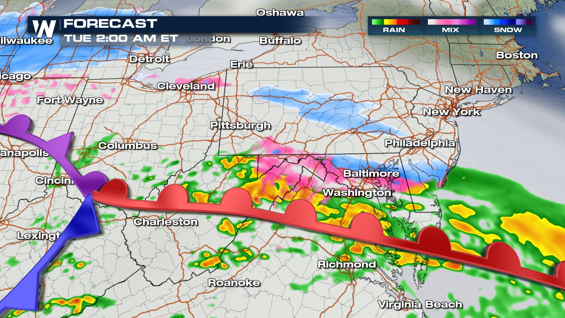
Forecast
As we head into Monday afternoon, most of the area is looking at heavy rainfall. Up in elevation throughout the Appalachians we start to see some icing and snowfall. The lift from the warm front provides us with ongoing precipitation.

As we lose some daytime heating after sunset, heavy snow starts to moves into the West Virginia, Maryland, Virginia, and southern Pennsylvania region.

From about 6 PM to 11 PM is when we can expect heavy snowfall rates as well as many areas that will get a coating of ice.

By Tuesday morning, the heaviest of the precipitation starts to slow down in intensity but still offering us accumulations through sunrise Tuesday. Eventually, this system tracks into the northeastern United States, stay tuned for the latest on that forecast.
A closer look
The Appalachia area is expected to see temperatures drop below freezing overnight which will give us the best chance for snowfall and ice accumulations.

Snow and Ice Forecast
Snow
Snowfall into the Appalachians is only expected to be up to 1-3″ with the highest amounts around West Virginia, Maryland and mostly west of the DelMarVa.

Ice Forecast
On the southern side of this system, we are expecting anywhere from 0.1″ of ice to isolated spots up to 0.5″. Keep in mind, ice accretion over 0.25″ becomes dangerous and that is typically where we run into major road problems and power outages.

That being said, the latest forecast for northeastern West Virginia and northwestern Maryland could see some isolated spots between 0.25 – 0.5″ of ice.

We have had some ice reports come in from southern Ohio through Kentucky, so far around a tenth of an inch has accumulated and likely more. Typically, over 0.25″ of ice is what will cause issues.

For the latest on the Mid-Atlantic through the rest of the Northeast be sure to tune into WeatherNation! Or be sure to follow the National Weather Service for the latest alerts.
Monday afternoon update: #Winter Weather headlines have been expanded to include portions of the I-95/US-29 corridor. There is still greater than usual uncertainty due to a layer of temperatures right around freezing; slightly colder = more snow/ice, slightly warmer = much less. pic.twitter.com/f5SeEyZwIt
— NWS Baltimore-Washington (@NWS_BaltWash) January 25, 2021


Comments
Something to say?
Log in or Sign up for free