


 User Center
 My Training Class
 Feedback


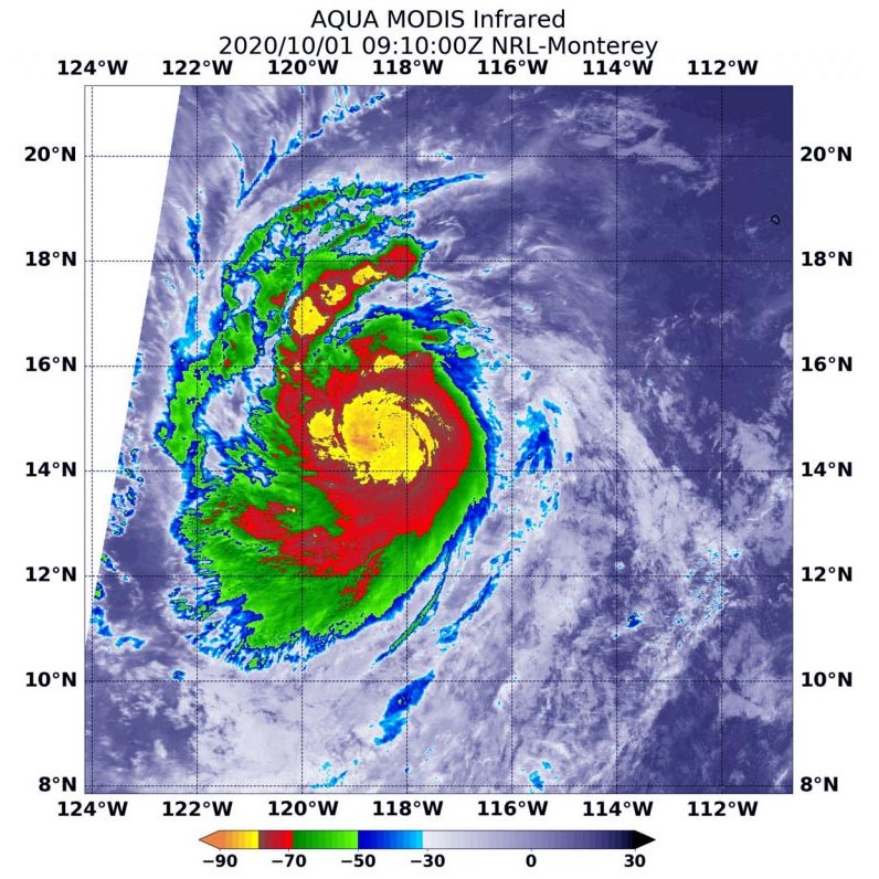
On Oct. 1 at 4:10 a.m. EDT (0910 UTC) NASA’s Aqua satellite analyzed Hurricane Marie’s cloud top temperatures and found strongest storms (yellow) were around Marie’s center of circulation. Temperatures in those areas were as cold as minus 80 degrees Fahrenheit (minus 62.2 Celsius). Strong storms with cloud top temperatures as cold as minus 70 degrees (red) Fahrenheit (minus 56.6. degrees Celsius) surrounded the center. Credit: NASA/NRL
NASA infrared imagery revealed that Hurricane Marie is rapidly growing stronger and more powerful. Infrared imagery revealed that powerful thunderstorms circled the eye of the hurricane as it moved through the Eastern Pacific Ocean.
NOAA’s National Hurricane Center (NHC) expects Marie to become a major hurricane late on October 1.
Infrared Imagery Reveals a More Powerful Marie
One of the ways NASA researches tropical cyclones is using infrared data that provides temperature information. Cloud top temperatures identify where the strongest storms are located. The stronger the storms, the higher they extend into the troposphere, and the colder the cloud top temperatures.
On October 1 at 4:10 a.m. EDT (0910 UTC) NASA’s Aqua satellite analyzed the storm using the Moderate Resolution Imaging Spectroradiometer or MODIS instrument. Hurricane Marie’s cloud top temperatures and found strongest storms were around Marie’s center of circulation. Temperatures in those areas were as cold as minus 80 degrees Fahrenheit (minus 62.2 Celsius). Strong storms with cloud top temperatures as cold as minus 70 degrees Fahrenheit (minus 56.6. degrees Celsius) surrounded the center.
NASA research has shown that cloud top temperatures that cold indicate strong storms that have the capability to create heavy rain.
At 5 a.m. EDT on October 1, NHC Hurricane Specialist Andrew Latto noted, “Recent microwave data and satellite images indicate that Marie has become much better organized over the past several hours, with a nearly completely closed eye noted in a (12:51 a.m. EDT) 0451Z AMSU composite microwave overpass.”
NASA then provides data to tropical cyclone meteorologists so they can incorporate it into their forecasts.
Marie’s Status on October 1
At 5 a.m. EDT (0900 UTC), the center of Hurricane Marie was located near latitude 14.8 degrees north and longitude 118.1 degrees west. It is about 775 miles (1,245 km) southwest of the southern tip of Baja California, Mexico. Marie is moving toward the west near 17 mph (28 kph), and this general motion is expected to continue through tonight, followed by a gradual turn toward the west-northwest with decreasing forward speed.
Maximum sustained winds are near 90 mph (150 kph) with higher gusts. Hurricane-force winds extend outward up to 15 miles (30 km) from the center and tropical-storm-force winds extend outward up to 70 miles (110 km). The estimated minimum central pressure is 983 millibars.
Marie’s Forecast
Rapid strengthening is forecast by the National Hurricane Center. Marie is expected to become a major hurricane by tonight with some additional strengthening possible through Friday. Marie is then forecast to begin weakening this weekend.
NASA Researches Earth from Space
For more than five decades, NASA has used the vantage point of space to understand and explore our home planet, improve lives and safeguard our future. NASA brings together technology, science, and unique global Earth observations to provide societal benefits and strengthen our nation. Advancing knowledge of our home planet contributes directly to America’s leadership in space and scientific exploration.


Comments
Something to say?
Log in or Sign up for free