Welcome to the IKCEST
Extreme Heat in Death Valley Monitored by ECOSTRESS on Space Station
Death Valley National Park Land Surface Temperature August 2020 Annotated

August 16, 2020. (Click image for high-resolution view.)

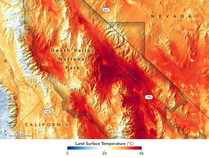
On August 16, 2020, temperatures in Southern California approached the highest levels ever reliably recorded on Earth. That day, NASA’s ECOsystem Spaceborne Thermal Radiometer Experiment on Space Station, or ECOSTRESS, collected a wide view of the heat wave across the region.

The map above shows land surface temperatures (LSTs) at 8:50 a.m. Pacific Daylight Time on August 16 around Death Valley National Park. Note that LSTs are not the same as air temperatures: They reflect how hot the surface of the Earth would feel to the touch and can sometimes be significantly hotter or cooler than air temperatures. Two days earlier, ECOSTRESS also collected late-afternoon heatwave data from Los Angeles and the San Fernando Valley.

Mounted on the outside of the International Space Station (ISS), ECOSTRESS uses a radiometer to measure thermal infrared energy emitted from Earth’s surface. It was specifically designed to gather insight into the health of vegetation, but it can also measure the “skin temperature” of Earth’s land surfaces. The unique orbit of the ISS enables ECOSTRESS to capture data at different times of day, as opposed to the regular (usually midday) observations made by many Earth-observing satellites. The sensor has a resolution of about 70 by 70 meters per pixel, about the size of a football field.

NASA Earth Observatory image by Joshua Stevens, using data courtesy of Kerry Cawse-Nicholson/NASA/JPL-Caltech and the ECOSTRESS science team.

Original Text (This is the original text for your reference.)

Death Valley National Park Land Surface Temperature August 2020 Annotated

August 16, 2020. (Click image for high-resolution view.)

On August 16, 2020, temperatures in Southern California approached the highest levels ever reliably recorded on Earth. That day, NASA’s ECOsystem Spaceborne Thermal Radiometer Experiment on Space Station, or ECOSTRESS, collected a wide view of the heat wave across the region.

The map above shows land surface temperatures (LSTs) at 8:50 a.m. Pacific Daylight Time on August 16 around Death Valley National Park. Note that LSTs are not the same as air temperatures: They reflect how hot the surface of the Earth would feel to the touch and can sometimes be significantly hotter or cooler than air temperatures. Two days earlier, ECOSTRESS also collected late-afternoon heatwave data from Los Angeles and the San Fernando Valley.

Mounted on the outside of the International Space Station (ISS), ECOSTRESS uses a radiometer to measure thermal infrared energy emitted from Earth’s surface. It was specifically designed to gather insight into the health of vegetation, but it can also measure the “skin temperature” of Earth’s land surfaces. The unique orbit of the ISS enables ECOSTRESS to capture data at different times of day, as opposed to the regular (usually midday) observations made by many Earth-observing satellites. The sensor has a resolution of about 70 by 70 meters per pixel, about the size of a football field.

NASA Earth Observatory image by Joshua Stevens, using data courtesy of Kerry Cawse-Nicholson/NASA/JPL-Caltech and the ECOSTRESS science team.

Comments

    Something to say?

    Log in or Sign up for free

    Disclaimer: The translated content is provided by third-party translation service providers, and IKCEST shall not assume any responsibility for the accuracy and legality of the content.
    Translate engine
    Article's language
    English
    中文
    Pусск
    Français
    Español
    العربية
    Português
    Kikongo
    Dutch
    kiswahili
    هَوُسَ
    IsiZulu
    Action
    Related

    Report

    Select your report category*


    Reason*


    By pressing send, your feedback will be used to improve IKCEST. Your privacy will be protected.

    Submit
    Cancel