Welcome to the IKCEST
Mysterious Red Circles in Satellite Image of Southern Ukraine Explained

Southern Ukraine From Space

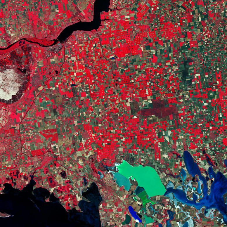
Southern Ukraine is featured in this false-color image captured by the Copernicus Sentinel-2 mission. This image was processed in a way that included the near-infrared channel, which makes vegetation appear bright red.

Owing to Ukraine’s climate and arable land, agriculture plays a large role in the country’s economy. In this image, captured on June 26, 2019, a patchwork of agricultural fields dominate the landscape. Ukraine’s main grain crops are winter wheat, spring barley and corn.

Circular shapes in the image are an example of center-pivot irrigation systems, where equipment rotates around a central pivot, and crops are watered with sprinklers.

The bright red contrasts with the black waters of the Kakhovka Reservoir on the Dnieper River, visible at the top of the image. Canals are visible as thin, black lines cutting through the agricultural fields, and are mostly used for water supply and irrigation of the surrounding farmlands.

In the far left of the image, the oval-shaped Oleshky Sands is visible. Covering an area of around 160 sq km., this large expanse of sand is considered a small desert in Ukraine. The grassy plains that used to cover the area are said to have died off hundreds of years ago owing to sheep farming – initiating the area’s desertification.

In the bottom-right of the image, a colorful network of salty lagoons lie along the northern border of the Crimean Peninsula. These shallow, marshy inlets are known as Syvash (also Sivash or Sivaš). During summer months, the warmer marsh waters leave unpleasant odors – earning the region the nicknames ‘Putrid Sea’ and ‘Rotten Sea.’

Copernicus Sentinel-2 is a two-satellite mission. Each satellite carries a high-resolution camera that images Earth’s surface in 13 spectral bands. The mission is mostly used to track changes in the way land is being used and to monitor the health of our vegetation.

Image: Contains modified Copernicus Sentinel data (2019), processed by ESA, CC BY-SA 3.0 IGO

Original Text (This is the original text for your reference.)

Southern Ukraine From Space

Southern Ukraine is featured in this false-color image captured by the Copernicus Sentinel-2 mission. This image was processed in a way that included the near-infrared channel, which makes vegetation appear bright red.

Owing to Ukraine’s climate and arable land, agriculture plays a large role in the country’s economy. In this image, captured on June 26, 2019, a patchwork of agricultural fields dominate the landscape. Ukraine’s main grain crops are winter wheat, spring barley and corn.

Circular shapes in the image are an example of center-pivot irrigation systems, where equipment rotates around a central pivot, and crops are watered with sprinklers.

The bright red contrasts with the black waters of the Kakhovka Reservoir on the Dnieper River, visible at the top of the image. Canals are visible as thin, black lines cutting through the agricultural fields, and are mostly used for water supply and irrigation of the surrounding farmlands.

In the far left of the image, the oval-shaped Oleshky Sands is visible. Covering an area of around 160 sq km., this large expanse of sand is considered a small desert in Ukraine. The grassy plains that used to cover the area are said to have died off hundreds of years ago owing to sheep farming – initiating the area’s desertification.

In the bottom-right of the image, a colorful network of salty lagoons lie along the northern border of the Crimean Peninsula. These shallow, marshy inlets are known as Syvash (also Sivash or Sivaš). During summer months, the warmer marsh waters leave unpleasant odors – earning the region the nicknames ‘Putrid Sea’ and ‘Rotten Sea.’

Copernicus Sentinel-2 is a two-satellite mission. Each satellite carries a high-resolution camera that images Earth’s surface in 13 spectral bands. The mission is mostly used to track changes in the way land is being used and to monitor the health of our vegetation.

Image: Contains modified Copernicus Sentinel data (2019), processed by ESA, CC BY-SA 3.0 IGO

Comments

    Something to say?

    Log in or Sign up for free

    Disclaimer: The translated content is provided by third-party translation service providers, and IKCEST shall not assume any responsibility for the accuracy and legality of the content.
    Translate engine
    Article's language
    English
    中文
    Pусск
    Français
    Español
    العربية
    Português
    Kikongo
    Dutch
    kiswahili
    هَوُسَ
    IsiZulu
    Action
    Related

    Report

    Select your report category*


    Reason*


    By pressing send, your feedback will be used to improve IKCEST. Your privacy will be protected.

    Submit
    Cancel