Language
We detect your regional language is French. Do you want to change site's language to French? You may choose other languages.International
 English
 中文
中文
 русск
русск
 français
 español
 العربية


 User Center
 My Training Class
 Feedback


Scientific Data (科学数据)
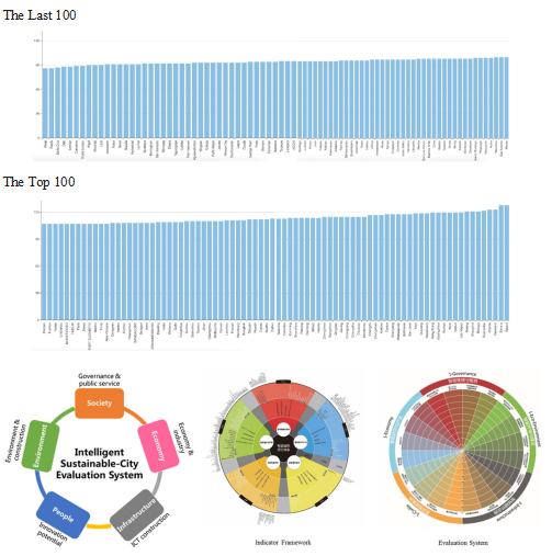
Latest Global CityIQ Ranking (最新全球城市IQ排名)
Introduction: The CityIQ column aims at developing a data model to provide evaluation services for global cities, undertaking sustainable development research tasks, relating to themes of urban planing, transportation, environment, safety and encouraging cities to provide data and best practices to support database construction and to improve the worldwide competences of city database and city evaluation system.
Source: Intelligent City Knowledge Service
Release date: Feb. 2021
Provided by: CAO Buyang
Video (视频课件)
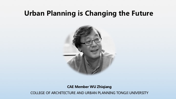
Urban Planning is Changing the Future (城市规划正在改变未来)
Introduction: CAE Member WU Zhiqiang believes that urban planning is particularly important for China. The history of urban development has repeatedly proved that the city as a human body needs to be organically combined with nature. Urban planning is not only to complete the artificial construction, but also to intervene in the ecological nature. Natural conditions are the first factor in urban planning, so it is necessary to integrate the artificial system and the natural ecosystem.
Source: Intelligent City Knowledge Service
Release date: Jan. 2021
Provided by: LI Xiang
Spatial Synergy and Supportiveness of Public Space (公共空间的空间协同与支撑)
Introduction: Professor Dieter Frick is from Technische Universität Berlinis. He is the former director of the institute of urban and regional planning at TU Berlin. He is a representative scholar in the field of urban planning theory in Germany. In this lecture he emphasizes the viewpoint, in contrast to the tradition of the Modern Movement, that public space has to be the decisive component in creating and developing settlement units that are habitable in the true sense.
Source: Intelligent City Knowledge Service
Release date: Feb. 2021
Provided by: LI Xiang

Scientific Data (科学数据)
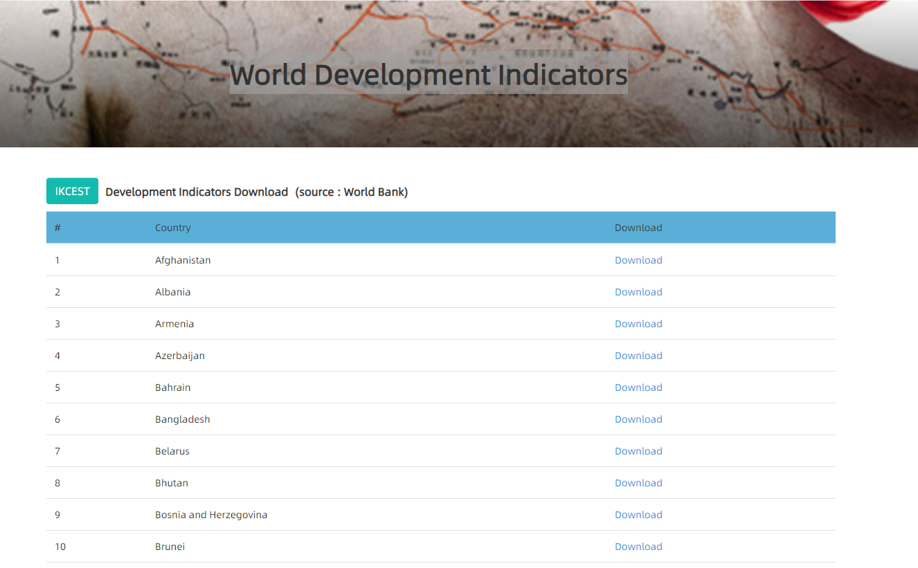
World Development Indicators- Bangladesh (世界发展指标-孟加拉国)
Introduction: It contains 55 data items from Bangladesh with a time span of 50 years (1968-2017) and supports visual display of data, including line, bar, scatter, and pie charts of indicators. It provides all information export functions. The data could be downloaded in Chinese, English, Russian and Arabic.
Source: Silk Road Sciences and Technology Knowledge Service
Release date: Feb. 2021
Provided by: Dong Yang
Knowledge Application (知识应用)
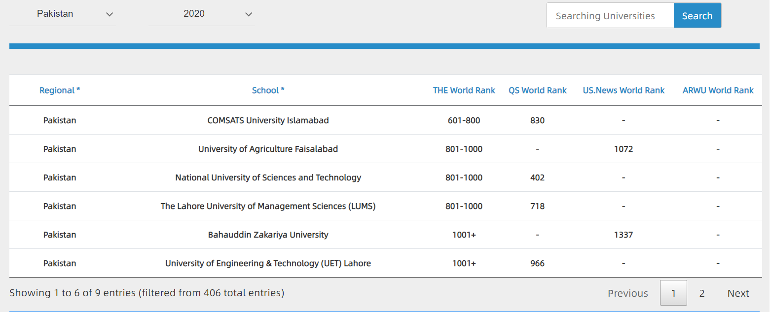
The World Rank of Pakistan University ("一带一路"高校排名-巴基斯坦)
Introduction: A knowledge application for comprehensive display and inquiry of Pakistan University is built to comprehensively display four internationally recognized world university rankings, such as QS, THE, US News and ARWU rankings, so as to facilitate engineering and scientific personnel from countries along the " Belt and Road" to select schools in countries along the " Belt and Road".
Source: Silk Road Sciences and Technology Knowledge Service
Release date: Feb. 2021
Provided by: Zhang Qianglong
Video (视频课件)
Appreciating Daoist classics (道家智慧)
Introduction: Confucianist and Daoist are the mainstream of Chinese culture. Confucianist shapes the social personality of the Chinese people. Daoist achieves the natural personality of the Chinese people. The core of "Dao" and "Nature" and "Inaction" are the basic categories, which have far-reaching influence on people's affairs and political philosophy. This course is divided into three major parts: the origin and mission of Daoist, the life of Laozi and the life of Zhuang Zi.
Source: Silk Road Sciences and Technology Knowledge Service
Release date: Feb. 2021
Provided by: Liu Jun
Scientific Data (科学数据)
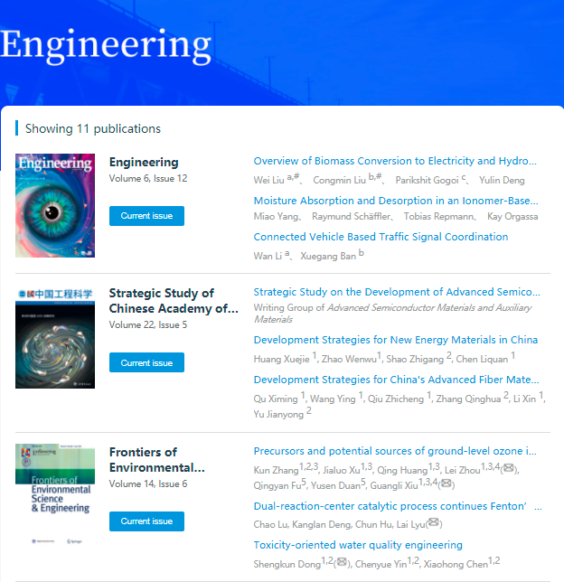
Engineering (《Engineering》期刊)
Introduction: In order to provide a platform for the top-level international exchange of engineering science and technology (EST) scholarship, as well as better guidance for the development of EST, the Chinese Academy of Engineering (CAE) is launching a world-class journal, Engineering, through cooperation with renowned experts and scholars in the EST communities. This journal covers all fields of EST, and reflects current EST development trends and progress in order to promote the exchange and exhibition of achievements. It includes Engineering and other 10 sub-journals: Strategic Study of Chinese Academy of Engineering, Frontiers of Agricultural Science and Engineering, Frontiers of Chemical Science and Engineering, Frontiers in Energy, Frontiers of Engineering Management, Frontiers of Environmental Science & Engineering, Frontiers of Information Technology & Electronic Engineering, Frontiers of Mechanical Engineering, Frontiers of Medicine and Frontiers of Structural and Civil Engineering. Recently, the Engineering is accessible on IKCEST platform. By accessing it, you can learn about cutting-edge advancements in engineering R&D, current major research outputs, and key achievements in EST.
Source: IKCEST General Platform
Release date: Feb. 2021
Provided by: Cai Lingli, Zhang Xinxing, Zhou Fan
Knowledge Application (知识应用)
Global Engineering Projects (全球工程)
Introduction: The knowledge service, Global Engineering Projects, brings together on a global scale innovative engineering projects that are representative of their own regions and fields. Recently, 10 new projects have been added to the Global Engineering Projects, which are representative projects in the fields of port, urban planning, infrastructure and so on. It can provide knowledge services, display frontier projects of major engineering’s research and development in various countries, analyze projects in detail from perspectives of technological innovation, scale benefit and social influence, and vividly present the general picture of each major engineering through pictures, texts and videos for you.
Source: IKCEST General Platform
Release date: Feb. 2021
Provided by: Cai Lingli, Zhang Xinxing, Zhou Fan

Scientific Data (科学数据)
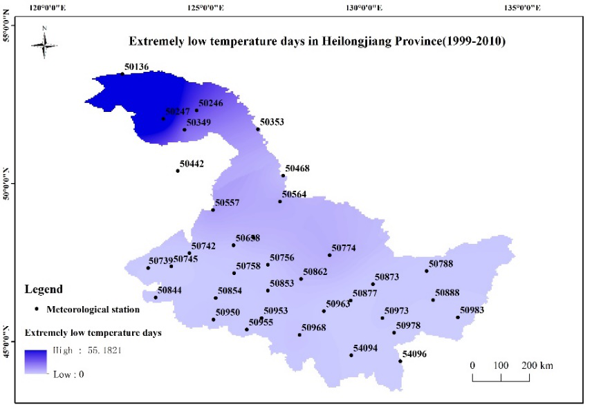
Extreme climate events in China-Russian border area (中俄毗邻地区的极端气候事件)
Introduction: Based on the daily air temperature, precipitation and other multi-source data of meteorological stations, the percentile threshold method is used to calculate the extremely low temperature, high temperature and precipitation days of each meteorological station. The spatial distribution characteristics of extreme weather events are obtained by using Kriging interpolation. The data set shows the extremely low temperature, high temperature and precipitation days in the adjacent regions of China and Russia: Heilongjiang Province and the coastal border region. It helps users to understand the temporal and spatial distribution of extreme weather events in this region, and provides a reference and basis for users and further research.
Source: Disaster Risk Reduction Knowledge Service
Release date: Jan. 2021
Provided by: Yuan Yuelei
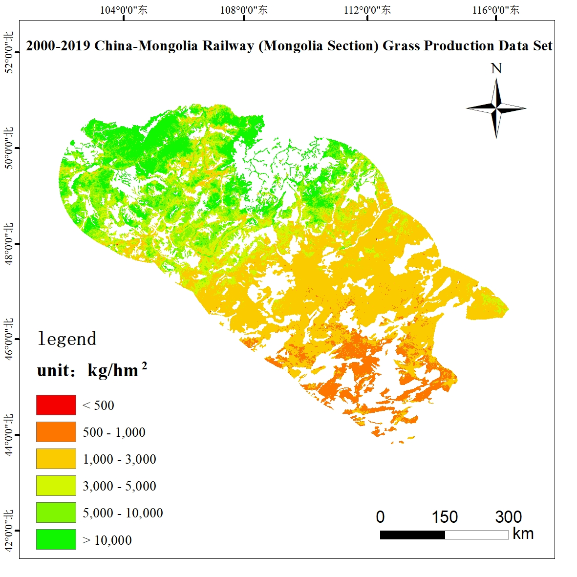
China-Mongolia Railway (Mongolia Section) Grass Production Data Set (2000-2019) (中蒙铁路(蒙古段)产草量数据集(2000-2019))
Introduction: This data set selects 200km buffer areas along both sides of the China-Mongolia Railway (Mongolia section) as the study area, and introduces the P-BSHADE method, based on the normalized differential vegetation index NDVI and a small amount of ground-measured sample data, to simulate evenly distributed samples Conduct an interpolation experiment. Based on the measured sample points and simulated sample points, combined with NDVI, enhanced vegetation index, and net photosynthetic vegetation index, the optimal model for estimating grass yield was established, and the annual grass yield data of the study area from 2000 to 2019 was retrieved and analyzed. Characteristics of temporal and spatial pattern changes.
Source: Disaster Risk Reduction Knowledge Service
Release date: Nov. 2020
Provided by: Yuan Yuelei
Knowledge Application (知识应用)
Knowledge Service of Annual Spatial Distribution Data Service for Drought Monitoring in Mongolian Plateau (1981-2012) (蒙古高原干旱监测逐年空间分布数据服务知识应用)
Introduction: The vegetation degradation, drought and other environmental issues in the Mongolian Plateau have been as the hot spot in the study of the climate change and the ecological environment changes in Northeast Asia. However, it is lack of study focused on building the stable drought monitoring model and their spatio-temporal differences between Mongolia and Inner Mongolia. Based on the NOAA AVHRR NDVI-Path Finder 10d remote sensing data of 1981-1999 and MODIS vegetation index and the surface temperature 16d data of 2000-2012, the knowledge service inverted Temperature and Drought Vegetation Index (TVDI) by the Ts-NDVI general space, their spatio-temporal distribution and changes were studied. The main conclusions are as follows: The inverted TVDI based on NOAA AVHRR NDVI-Path Finder and MODIS data, could explain the macro spatio-temporal distribution and changes of drought. The vegetation cover and drought in the Mongolian Plateau has obvious zonal distribution, and closely related with the Land Use/Land cover types. Drought is common in the Mongolian Plateau, and it is severe drought in some years. There were differences between the changes of TVDI in different regions of different Land Use/Land Cover.
Source: Disaster Risk Reduction Knowledge Service
Release date: 2018
Provided by: Yuan Yuelei
Video (视频课件)
A new solution for flash flood and debris flow: Disaster prediction and integrated risk reduction (用于山洪和泥石流的新解决方案:灾害预测和综合风险降低)
Introduction: China suffers from various disasters for a long time, such as flash floods, debris flows and so on. And China has done a lot of work to control floods. Flash floods and debris flows always occur in mountainous areas. How to move people to safer places? A very important task is to carry out disaster prediction. This report will introduce a new solution for flash floods and debris flows, which is mountain disaster simulation and risk assessment system. The system provides basic data and risk assessment model which are needed for disaster risk analysis, and a variety of online risk assessment tools. In this way, risks can be assessed and risk mapping can be carried out. This system has been used to evaluate disaster risks of the whole Sichuan-Tibet railway, and the evaluation results are with great reference value.
Source: Disaster Risk Reduction Knowledge Service
Release date: 2021
Provided by: Yuan Yuelei
>>>IKCEST Newsletter 2020 December<<<
>>>IKCEST Newsletter 2020 October<<<