Language
We detect your regional language is French. Do you want to change site's language to French? You may choose other languages.International
 English
 中文
中文
 русск
русск
 français
 español
 العربية


 User Center
 My Training Class
 Feedback


Dear Sir/Madam:
This is the latest news and knowledge service information of the International Knowledge Centre for Engineering Sciences and Technology under the Auspices of UNESCO.If you have any comments or suggestions on the information and services we provide, you can reply to this email or click "FEEDBACK" at the end of the email.We welcome you and thank you for visiting the webiste (https://www.ikcest.org) .Best wishes!
尊敬的用户:
您好!这是联合国教科文组织国际工程科技知识中心(IKCEST)本月推送的简报和知识服务信息,欢迎您访问我们的网站 (https://www.ikcest.org) 获取更多精彩内容。 如果您对我们提供的信息和服务有任何意见或建议,可直接回复本邮件或通过点击邮件末尾的 “FEEDBACK” 进行意见反馈。 感谢您对IKCEST的支持!祝好!
Knowledge application (知识应用)
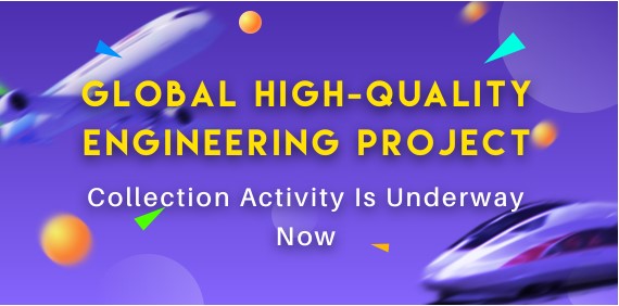
Global High-Quality Engineering Project Collection Activity(全球优质工程案例征集行动)
Introduction: Quite a few projects have been built by countries around the world, hence reflecting the achievements made by the development of human society. They deserve to be recorded and summarized. To be able to record the historical steps of human beings and provide convenience for people to consult engineering information, the International Knowledge Centre for Engineering Sciences and Technology (IKCEST) under the auspices of UNESCO launched the Global High-Quality Engineering Project Collection Activity in 2020 to collect engineering project information from residents of the global village. Join us in the collection activity because you are exactly the recorder of the time that we are looking for!
Source: IKCEST General Platform
Release date: Sept. 2020
Provided by: Cai Lingli, Zhang Xinxing, Zhou Fan
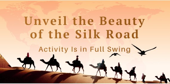
Unveil the Beauty of the Silk Road Activity(点亮"一带一路",寻找丝路之"美"活动)
Introduction: When the distant ringing sound of camel bells crosses the starry sky of history, the desolate smoke and falling geese in the past seem to be magically transformed into one winding rail track after another. The ancient Silk Road has once again sent off its radiant glow. The long Silk Road is laden with “beautiful scenery” in the world and is imprinted with lesser-known glories. The International Knowledge Centre for Engineering Sciences and Technology (IKCEST), a category II centre under the auspices of UNESCO, has launched the activity of Unveil the Beauty of Silk Road to collect information on the “beautiful” scenery of countries along the Belt and Road and boost information exchange among these countries. IKCEST is now sincerely inviting you as a local reporter to cover the most stunning scenery of your country along the Belt and Road and share it with the rest of the world!
Source: IKCEST General Platform
Release date: Sept. 2020
Provided by: Cai Lingli, Zhang Xinxing, Zhou Fan
Scientific Data (科学数据)
Historical mean wind speed monitoring data set for The Belt and Road(1989-2018)(“一带一路”历史平均风速监测数据集(1989-2018))
Introduction: The data set is calculated and interpolated by weather station data. The meteorological site data comes from NOAA, which includes data such as temperature, wind speed, and precipitation. The research team processes the daily weather station data into monthly data, and then interpolates through Kriging to form raster data covering the entire study area.
Source: Disaster Risk Reduction Knowledge Service
Release date: Jun. 2020
Provided by: Yuan Yuelei
Basic national information database of Bosnia and Herzegovina(波黑基础国情数据库)
Introduction: The basic geographical national information data of countries and regions along the Belt and Road, is an important basis for disaster risk reduction. The basic geographical national information dataset of Bosnia and Herzegovina includes three categories, namely, basic national condition, natural resources, politics and economy. The detail elements in the classification include geographical location, administrative division, topography, soil, climate, rivers and lakes, environment, land resources, water resources, forest resources, animal resources, plant resources, energy resources, mineral resources, non-metallic mineral resources, tourism resources, language, nationality, religion, festivals, political diplomacy, economy, science and technology, education, sports, hospital bed density, etc.
Source: Disaster Risk Reduction Knowledge Service
Release date: May 2020
Provided by: Yuan Yuelei
Knowledge application (知识应用)
Knowledge Application of Temporal and Spatial Distribution of Public Sentiment in Shouguang Flood(寿光洪水泛滥时空分布的知识应用)
Introduction: Social media has been applied to all natural disaster risk-reduction phases, including pre-warning, response, and recovery. However, using it to accurately acquire and reveal public sentiment during a disaster still presents a significant challenge. To explore public sentiment in depth during a disaster, this study analyzed Sina-Weibo (Weibo) texts in terms of space, time, and content related to the 2018 Shouguang flood, which caused casualties and economic losses, arousing widespread public concern in China. The temporal changes within six-hour intervals and spatial distribution on sub-district and city levels of flood-related Weibo were analyzed. Based on the Latent Dirichlet Allocation (LDA) model and the Random Forest (RF) algorithm, a topic extraction and classification model was built to hierarchically identify six flood-relevant topics (table1) and nine types of public sentiment (table2) responses in Weibo texts. The majority of Weibo texts about the Shouguang flood were related to “public sentiment”, among which “questioning the government and media” was the most commonly expressed. The Weibo text numbers varied over time for different topics and sentiments that corresponded to the different developmental stages of the flood. On a sub-district level, the spatial distribution of flood-relevant Weibo was mainly concentrated in high population areas in the south-central and eastern parts of Shouguang, near the river and the downtown area. At the city level, the Weibo texts were mainly distributed in Beijing and cities in the Shandong Province, centering in Weifang City. The results indicated that the classification model developed in this study was accurate and viable for analyzing social media texts during a disaster. The findings can be used to help researchers, public servants, and officials to better understand public sentiments towards disaster events, to accelerate disaster responses, and to support post-disaster management.
Source: Disaster Risk Reduction Knowledge Service
Release date: 2019
Provided by: Yuan Yuelei
Video (视频课件)
Resources and Environmental Scientific Data Integration and Sharing in the Belt & Road area(“一带一路”地区资源环境科学数据整合与共享)
Introduction: Scientific Data Curation has been a hot spot in the field of professional disciplines, information science and library science. This course focuses on the research trend and practice of data integration and sharing of resources and environmental science in the Belt and Road area. Including:1. International trends of scientific data sharing; 2. Data collection and integration in North East Asia; 3. Spatial Pattern of multiple resources and environmental elements in the B&R area based on data integration;4. land use/cover changes on the Mongolia Plateau based on data analysis ;5. Framework of the Belt and Road spatial information system based on data sharing cooperation.
Source: Disaster Risk Reduction Knowledge Service
Release date: 2019
Provided by: Yuan Yuelei
Near-Real-Time monitoring of land surface state by land surface model and satellite products(利用地表模型和卫星产品对地表状态进行近实时监测)
Introduction: Near real-time high resolution land surface analysis is running operationally for Japan region. Atmospheric forcing data is created based on global analysis near surface field and satellite derived precipitation (GSMAP) and downward shortwave radiation (EXAM). This system produces surface energy/water balance components and surface state variables. This system can be easily applicable to other region in the HIMAWARI-8 cover area.
Source: Disaster Risk Reduction Knowledge Service
Release date: 2018
Provided by: Yuan Yuelei
Scientific Data (科学数据)
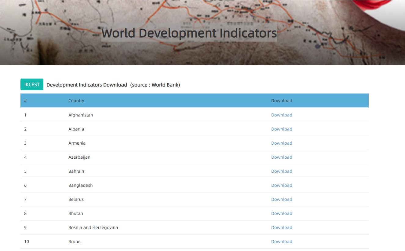
World Development Indicators-Azerbaijan(世界发展指标-阿塞拜疆)
Introduction: It contains 55 data items from China with data spanning 50 years (1968-2017) and visual display of data, including line, bar, scatter, and pie charts of indicators. It provides all information export functions. It supports Chinese, English, Russian and Arabic language download.
Source: Silk Road Sciences and Technology Knowledge Service
Release date: Oct. 2020
Provided by: Dong Yang
Knowledge application (知识应用)
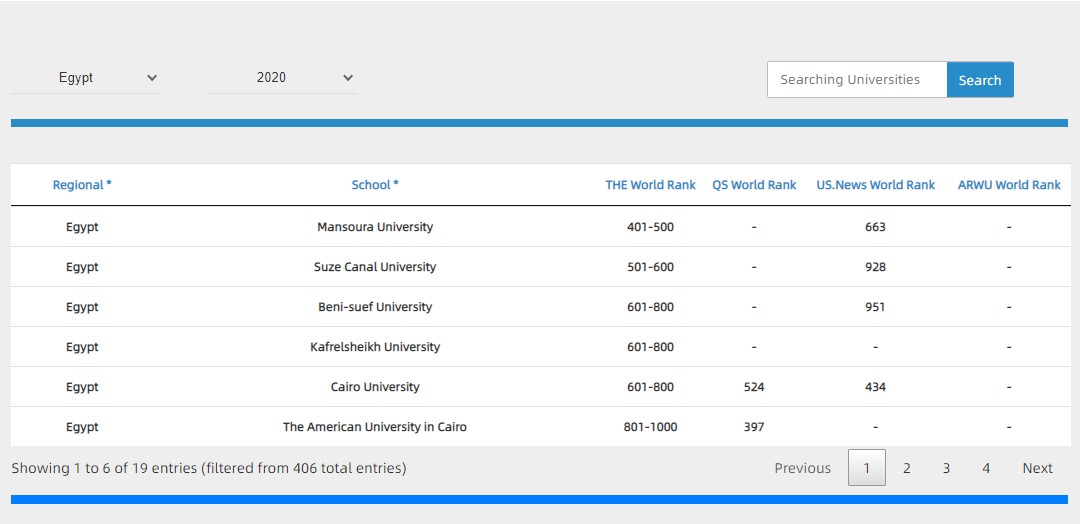
The World Rank of Egypt University(“一带一路”高校排名-埃及)
Introduction: A knowledge application for comprehensive display and inquiry of Estonia University is built to comprehensively display four internationally recognized world university rankings, such as QS, THE, US News and soft science world university rankings, so as to facilitate engineering and scientific personnel from countries along the " Belt And Road" to recruit students and choose schools in countries along the " Belt And Road".
Source: Silk Road Sciences and Technology Knowledge Service
Release date: Oct. 2020
Provided by: Zhang Qianglong
Video (视频课件)
Welfare economics(福利经济学)
Introduction: Welfare economics is a discipline that studies government behavior using the basic theories and methods of economics. The course of welfare economics is a compulsory course for major students in the School of Public Policy and Administration. This course mainly includes the following contents: fundamental theories (welfare economics, externality theory, government intervention theory, public goods theory) and basic theories (public income theory, public expenditure theory, public choice theory, public regulation theory).
Source: Silk Road Sciences and Technology Knowledge Service
Release date: Oct. 2020
Provided by: Liu Jun
Scientific Data (科学数据)
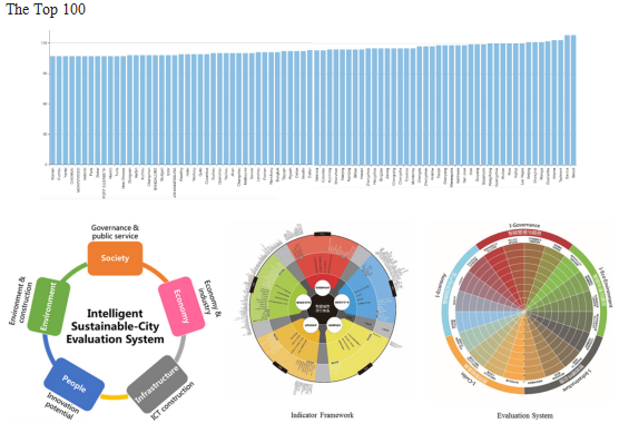
Latest Global CityIQ Ranking(最新全球城市IQ排名)
Introduction: The CityIQ column aims at developing a data model to provide evaluation services for global cities,undertaking sustainable development research tasks, relating to themes of urban planing, transportation, environment, safety and encouraging cities to provide data and best practices to support database construction and to improve the worldwide competences of city database and city evaluation system.
Source: Intelligent City Knowledge Service
Release date: Oct. 2020
Provided by: CAO Buyang
Video (视频课件)
Prospect of urban top technologies in 2035 (2035城市置顶技术展望)
Introduction: CAE Member WU Zhiqiang summarizes the ten basic backgrounds of urban development in 2035, and systematically looks forward to the nine major fields of future urban top technology, as well as 100 special technologies involved, outlines a panoramic blueprint for the goal of "urbanization and urban development" in China's next 15 years' national medium and long-term plan, provides a panoramic blueprint for accurate recognition and grasping the law of urbanization and urban development.
Source: Intelligent City Knowledge Service
Release date: Sept. 2020
Provided by: LI Xiang
Planning discipline and education: adapting to the transition from urban and rural planning to territorial space planning (规划学科和教育:适应从城乡规划到国土空间规划的转变)
Introduction: Professor SUN Shiwen discusses the main transformation from urban and rural planning to land and space planning from the perspective of planning system, object, content and management and control mode; the orientation of urban and rural planning discipline should be multi-disciplinary of land and space planning. He also suggests we should improve the overall framework of planning from the three levels of ontology, epistemology and methodology, establish a complete logic chain of strategy strategy policy measures, enhance the thinking ability of transformation, improvement and problem-solving.
Source: Intelligent City Knowledge Service
Release date: Sept. 2020
Provided by: LI Xiang
>>>IKCEST Newsletter 2020 August<<<
>>>IKCEST Newsletter 2020 June<<<